
MDT does not have enough information to say how long any of these restrictions will be in place. Please use alternate routing when applicable. Please visit https://www.511mt.net/ for more information on incidents and closures.
S-482 Farm To Market Rd Libby, MT MP 2.0 to 3.0
Effective 3/17/2026. Road Closed due to flooding.
I-90 EB Bear Canyon MP 313.0 to 313.6
Effective 1/21/2026. All lanes CLOSED. Detour and width limit of 24 feet. Eastbound lanes closed for bridge damage. Detour for eastbound traffic starts at MP 312. Exit 313 Bear Canyon Underpass is closed both directions.
NW Montana Flooding
Effective 12/11/2025. A state of emergency was declared by Governor Greg Gianforte around noon on Thursday, December 11, for Lincoln County due to heavy rains and extensive flooding in the Libby and Troy areas. See information at NW Montana Flooding - Libby, Montana.
Updated road closures and bridge information.
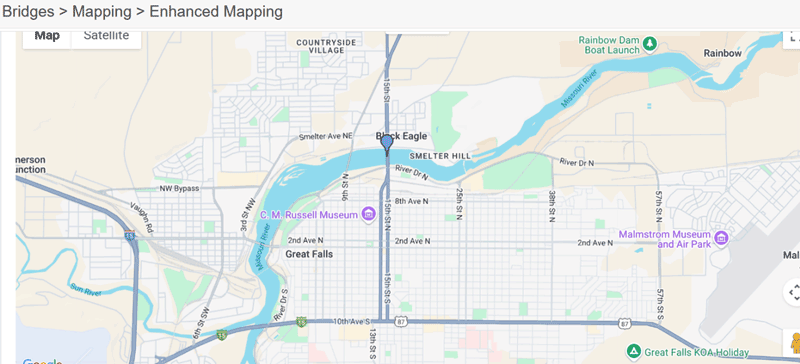
15th Street Bridge over the Missour River in Great Falls, MT
Effective 06/24/2025
No Overweight Loads will be permitted over this bridge until further notice. If you have questions or concerns please feel free to contact MCS at 406-444-7262.
Hwy 91 Big Hole River Bridge 22 Miles N of Dillon
Effective 10/22/2024. Full closure of the Big Hole River Bridge that carries Hwy 91 approximately 22 miles north of Dillon.
Latitude: 45.526644 and Longitude: - 112.701969
The bridge can no longer carry traffic safely or reliably and will remain closed until further notice.
US-2 Bridge over Kootenai River
Effective 03/07/2024. No overweight loads, loads over legal weight, including permitted loads, are prohibited until further notice from using the US-2 Bridge over Kootenai River at milepost 11.6. The Bridge is approximately 2 miles northwest of Troy, MT.