
Overview
A portion of Montana State Primary Route 69 (MT 69) south of Boulder, in Jefferson County, has been nominated for rehabilitation/reconstruction.
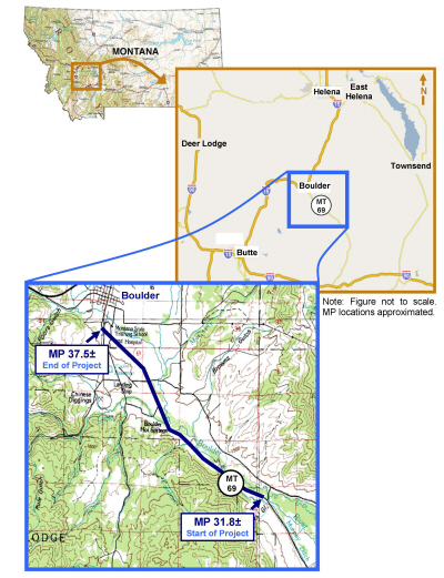
The proposed project is located in Jefferson County on MT 69. It begins at MP 31.8± and extends to the north approximately six miles, ending at MP 37.5± just south of Boulder.
As shown in the figure below, the proposed project is located within the following legal description(s):
| Township | Range | Sections(s) |
|---|---|---|
| 5 N | 3 W | 18, 19 |
| 5 N | 4 W | 2, 3, 4, 10, 11, 13, 14, 24 |
| 6 N | 4 W | 32, 33 |
Purpose of the Project
The purpose of reconstruction of MT 69 is to improve safety for users of the project corridor while mitigating project impacts to the surrounding built and natural environments.
Need for the Project
A preliminary review of the existing horizontal and vertical alignment of the roadway indicates that improvements in the roadway design could provide substantial safety improvements in the corridor.
As shown in Table 1.1, the all-vehicle crash rate for the portion of MT 69 from MP 31.8± to MP 37.5± over the period January 1, 1998 through December 31, 2007 was approximately 44 percent greater than the statewide average crash rate for rural state primary highway systems. Over the same period, the all-vehicle severity rate was over 17 percent greater than the statewide average. Additionally, the percentage of crashes involving trucks over this portion of MT 69 was approximately 27 percent greater than the percentage of crashes involving trucks for all rural state primary highways over the same time period. There have been 23 injuries and one fatality during the period from 1998 through 2007.
Table 1.1 - Crash History Comparison
| Criteria | Rural State Primary Highways (1998-2007) | MT 69 MP 31.8± - 37.5± (1998-2007) |
|---|---|---|
| Weighted AADT | NA | 1,199 |
| Total Number of Crashes | 15,495 | 51 |
| Crash Rate (All Vehicles) | 1.42 | 2.04 |
| Severity Index (All Vehicles) | 2.41 | 1.96 |
| Severity Rate (All Vehicles) | 3.41 | 4.00 |
| Total Number of Crashes Involving Trucks | 1,193 | 5 |
| Percentage of Crashes Involving Trucks | 7.7% | 9.8% |
| Snow, Slush, and Ice Pavement Conditions at Time of Crash (All Vehicles) |
3,080 | 9 |
| Dark Not Lighted at Time of Crash (All Vehicles) |
4,887 | 15 |
| Source: Montana Department of Transportation, 2008 | ||
Single-vehicle off-road accidents resulting in overturn are of particular concern in this corridor. Of all crashes that occurred during the period January 1, 1998 through December 31, 2007, nearly 73 percent (37 out of 51) involved single vehicles. Of these, 30 percent (11 out of 37) resulted in overturn. An additional crash involving two vehicles also resulted in overturn. According to the May 2004 Preliminary Field Review Report (PFRR) prepared for this project, some factors contributing to this type of crash on MT 69 include narrow to non-existent shoulders, a sharp horizontal curve near MP 36.1±, and vertical crest curves that do not meet minimum Stopping Site Distance (SSD) guidelines. This safety improvement project would address these geometric features where practicable.
Conflicts with wild and domestic animals is another concern in the project corridor. Of all crashes over the period January 1, 1998 through December 31, 2007, just over 21 percent (or 15 crashes out of 51 total crashes) involved collisions with animals. Of these 15 crashes, one-third (or 5 out of 15) involved domestic animals, while the remaining two-thirds (or 10 out of 15) involved wild animals. Widening the roadway's top width, clearing side slopes, and making improvements to SSD in the corridor are some of the features proposed under this project in an attempt to reduce the number of collisions with animals on MT 69.
The portion of MT 69 between MP 31.8± and MP 35± experiences periodic icing due to shading from the rock outcropping, which likely contributes to the incidence of crashes. Nine of the 28 accidents over this portion of the corridor occurred under icy or snowy roadway conditions.
In addition to the high incidence of crashes on MT 69, the roadway has also outlived its design life. This means that the pavement surfacing and roadway base have begun to deteriorate and will continue to do so if no improvements are made.
Expected Schedule
The Montana Department of Transportation will manage the Boulder - South project and lead a team of consultants to complete the EA document in 2011. (Expected Project Schedule)