
What is a multimodal street classification system?
Functional classification of highways is a common practice in the US. Traditionally, highways are classified based on the type of vehicular travel (local vs. through traffic). Roads would be classified as either urban or rural, and as a principal arterial, minor arterial, collector, or local road.
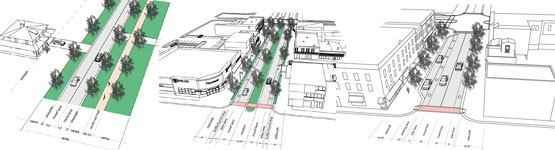
Multimodal street classification systems categorize a jurisdiction's streets into a hierarchy of classifications organized by function and community context, taking into account all road users, not just automobiles. Streets of different scales serve different purposes. To maintain the highest levels of safety, the function of the road must be clearly identified and the needs of all its users must be addressed. For example, balancing the safety needs of drivers and pedestrians is very difficult on a roadway that allows high speeds and unlimited access points.
To address this concern, multimodal street classification systems can be used to define the function of a road and guide decisions for appropriate land development and access management strategies, as well as transportation improvements. A limited access "parkway," for example, would be designed to support regional, heavy-volume, and high-speed vehicle traffic. "Main Streets," by contrast, would accommodate more local traffic moving at lower speeds, provide access to many destinations within a small area, and feature bicycle and pedestrian facilities within the right-of-way. Street classifications can also specify the appropriate accommodations for transit service.
Who can implement it?
Local municipalities can implement multimodal street classification systems, as was done in Denver, CO and Charlotte, NC. Localities may be best suited to implement because classifying streets into different classifications takes time and in-depth comprehensive knowledge of the entire area, especially the functions of each road within the jurisdictional boundaries and the characteristics and travel behavior patterns of the people who use the road.
States can implement multimodal street classification systems, but this may be burdensome due to the large land area of some states and the thousands of miles of road network. Multimodal street classifications are not common in Montana. Important Montana statewide policy documents relevant to multimodal considerations in the design process are the MDT Road Design and Traffic Engineering Manuals and MDT Context Sensitive Solutions Guide. Design options are considered based on the federal functional classification of a roadway. These are described in more detail on the Roadway Design Manuals and Guidelines page.
What are the keys to success and potential pitfalls?
Implementing a street classification system will take a lot of time for full integration into the land development decision making process. To ensure success, all parties involved in the design and approval of development should be aware of and understand the classifications. The planning and public works departments must work together during the creation of the document, and continue to work together through the approval process and implementation. Because developments go through many different stages of drafting, negotiation, approval and construction, it is crucial to have each agency along the way be familiar and enforce the guidelines in the street classification system.
While street classifications will be easy to implement for new development, infill development can present many challenges. Constrained right-of-way and existing high volumes of traffic make retrofitting existing streets difficult. Tradeoffs between access, mobility and environmental design will have to be made. Decision-makers must contemplate all options with due diligence to find the best solution.
In determining the classification of streets, it is important to consider not only the projected traffic volumes, street width and number of lanes, but also the adjacent land uses, regional connections, and function of the road. Questions to ask include: Does this road serve mostly local or through traffic, or a mix of both? Should trucks be permitted? Is this road suitable for transit service? Are there adequate bicycle and pedestrian facilities? How do the current conditions of this street fit into the context of local area planning? What could the future of this street look like?
Where has this strategy been applied?
Examples in Montana
Although multimodal street classifications are not common in Montana communities, a number of localities have incorporated Complete Streets into their planning policies.
- The 2008 Missoula Long Range Transportation Plan includes the following key policy objective (pages E-3, 1-2): Encourage a "Complete Streets" policy that provides multi-modal facilities, including public transportation and pedestrian improvements. Responses to various public comments on the LRTP indicate a "Complete Streets" policy was one of the major goals areas of the plan.
- The Greater Bozeman Area Transportation Plan (2007 Update) includes a discussion of complete streets concepts and a set of Complete Streets guidelines recommended for adoption by the City of Bozeman and Gallatin County. The plan also includes discussion on context sensitive design/context sensitive solutions to help ensure transportation improvements are appropriate for their surrounding environment and accommodate all modes.
Examples outside of Montana
- Blueprint Denver, an integrated land use and transportation plan for the City and County of Denver, includes a street classification system that considers multiple modes and surrounding land uses. Areas are designated as residential streets, main streets, mixed use streets, commercial streets, and industrial streets. The system includes six functions for roadways along with street typologies. By using the functions and street typologies together, planners can more precisely characterize streets. State highways are included in typology, but not controlled access freeways. Street typologies used as a starting point in the developmental review process by the Denver zoning, planning, and engineering staff reviewing private development proposals. The multimodal street concept included in zoning amendments, transportation and land use plans, and in design guidelines for local redevelopment projects.
- The City of Charlotte, NC included revised Urban Street Design Guidelines for construction or reconstruction of major streets and local streets. Street typologies are used to reflect levels of auto and alternative transportation priority. The guidelines allow for the design of neighborhood-appropriate streets, such as traditional downtowns, transit-oriented developments, urban residential and mixed-use, and suburban areas.
- The City of Alameda, CA's public works department is working on a Multimodal Circulation Plan, which will result in the functional classification system for the city's street. the classification system is designed to become part of the city's Transportation Master Plan and the Transportation Element of the General Plan. The intent is to determine the most appropriate use of streets and consider the needs of all users of all modes of transportation - motor vehicles, buses, bicycles, pedestrians, trucks and ferries.
How can I get started?
Creating a well-rounded project team should be the first step in the process of creating a multimodal street classification system. It is important to have in-depth knowledge on a variety of topics including development approval, construction, traffic engineering, planning and urban design, and land development policy. Discussing the area's road network, particularly identifying the function of the roads within the transportation system is key. Informed knowledge about the context of the surrounding community is absolutely crucial.
Where can I get more information?
- Designing Walkable Urban Thoroughfares: A Context Sensitive Approach. This 2010 resource from the Institute of Transportation Engineers provides extensive discussion on thoroughfare type and functional definition, and design standards associated with each classification.
- Bockner, B., and F. Dock, 2003, "Street Systems and Classifications to Support Smart Growth," Second Urban Street Symposium, Anaheim, California.
- Strate, H. E., et al., "Functional Classification for Multimodal Planning," Transportation Research Record.